Swamp Lake Trail, CA

BONDSY

Member
Nestled in the High Sierra Mountains east of Fresno, CA is a trail in which I love to run. This trail is Swamp Lake.
Rated a difficult trail in the C. Wells "Guide to Calif. Backroads & 4 Wheel Drive Trails" this trail offers many opportunities to test your wheeling skills, and offers some of the most scenic views, lakes, meadows, and camping. A lengthy 13.4 miles long the trail can be done in a 7 hour day if your JK has the proper equipment. I attempted to document all the tougher spots on this trail to give you perspective of what you can expect. I sure hope you enjoy the pics I took and, I hope you too will take the time to enjoy this trail as much as I do. Also, all the pics you will see was taken with the Iphone 4.
Enjoy:
8085ebce.jpg

At this point I have already aired down, it's 8:00 am:
05261aef.jpg

Installed the Crawl Tune:
ab44cf01.jpg

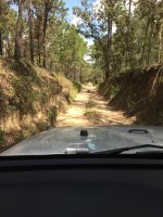
The trail leading up to the first ridge:
6d99ca69.jpg

c67c6f93.jpg

adbe4c36.jpg

0a26f9d0.jpg

A rocky section:
d6009d0f.jpg

68145e5f.jpg

This time of year the flowers are in bloom:
c8add70e.jpg

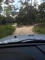
This trail also has open spaces and narrow spots winding through the trees:
ef62262d.jpg

Emergency supplies:rotflmao2: And yes I was wearing a cowboy hat, bumping old country tunes too:
0ff34a6a.jpg

A view:
89b2775d.jpg

ac5cf234.jpg

Some of the snow still hanging on. There were still 12" banks a month ago:
2eec8530.jpg

You know, there are many unsung hero's who every year are chomping at the bit to clear these trails for us to enjoy. I solute you. One of the trees the cleared:
9ef2b46f.jpg

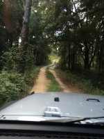
Pretty to drive through this:
8b9c0f1d.jpg

c7eab368.jpg

Up until this point of the trail the difficulty has been minor. It changes now:
a205bd5b.jpg

ae177fc4.jpg

dcd3565d.jpg

Stretching a little:
5339e911.jpg

27669208.jpg

b9952272.jpg

The tougher spots as I make my way to the second ridge:
5308eab6.jpg

ae290cb1.jpg

3ce53fb2.jpg

560feb03.jpg

e13724af.jpg

23a82082.jpg

Rocky and narrow:
cde21619.jpg

3a22e2e6.jpg

7638ff3e.jpg

730cc323.jpg
 

BONDSY

Member
Some spots are difficult to find the trail:
95860250.jpg

537ff080.jpg

12cb6b68.jpg

Just on the left of my JK is Rooster Rock:
bfcc6c50.jpg

Another awesome view:
40087b57.jpg

Grouse Lake is at 7.9 miles:
4a347774.jpg

6624b8f1.jpg

Working my way up to the second ridge which is about 9600"
4dd936c8.jpg

63e950d4.jpg

005ea5f9.jpg

From the top of the second ridge, looking down at Swamp Lake and Meadow:
17edc961.jpg

b3cc189b.jpg

At this point of the trail you descend rapidly down hill but this mine is along the way:
2c77c20e.jpg

9fe031c9.jpg

1cfe2f59.jpg

This is Swamp Lake and the Camp site. Restroom are here too:
cd4d85bb.jpg

b84f1716.jpg

ca9915e6.jpg

That is snow on the other side of the lake:
1e25a396.jpg

b49cc14a.jpg

Peaking through the trees is the Meadow. One of the prettiest I've seen:
e84380b2.jpg

47c372af.jpg

9739029f.jpg

8cbe7abd.jpg

d57e5a48.jpg

f89447c1.jpg

63c1fc18.jpg

bbf3fc83.jpg

At the Meadow there is an old snow survey cabin:
990b450e.jpg

The trail is flat and smooth for a bit, but don't be fooled:
e41026a8.jpg

50847d88.jpg

dc27c4c4.jpg

Unforgiving rock gardens will test you:
cd92998d.jpg

d393a81a.jpg

48c7f2bf.jpg

704cb1de.jpg

1993fda8.jpg

You get a break for a bit:

4bc131f2.jpg

Then this, more rocks:
ab32b947.jpg

32f4f5c5.jpg

20e34b96.jpg

This is why I bought EVO Sliders:
4d32fd5d.jpg

361ef680.jpg

d53fe7b1.jpg

Up and over:
22dd46b7.jpg

1d409f45.jpg

195d221c.jpg

Getting some more flex:
2d6dfa19.jpg

Rock gardens again. I love these sections of trail:
a27acf2e.jpg

11d589ab.jpg
 

BONDSY

Member
Rocks Continued:
11d589ab.jpg

7ee61db2.jpg

The trail eases up for a bit and you see treats like this:
be1df3f0.jpg

90a4877a.jpg

6a23d357.jpg

61480e70.jpg

The down hill descent to Miningtown Meadow is a tough one. And up till this point dust on the trail wasn't an issue due to rain the day before:
Here we go on the last leg of the trail:
387c8b13.jpg

9c1944dc.jpg

20307202.jpg

4e6f3905.jpg

Thanks again to the folks who clear these trails:
7d3eb576.jpg

3168da58.jpg

Miningtown Meadow:
ed1917fe.jpg

Just before the end of the trail there is a old mining area:
19769c38.jpg

cb1227ba.jpg

cc207722.jpg

ec4cffa3.jpg

475f9dbf.jpg

b36a6469.jpg

Almost to the northern gate and a creek crossing to cool of the tires:
8068a6ae.jpg

7bbc3635.jpg

43199021.jpg

1a5fc240.jpg


Generally this trail is run from the south to the north. At this gate the time was 2:40 pm.
Here is a link to all of the photos I took of this trip:
http://s1005.photobucket.com/albums/af176/bondsy/Swamp Lake Route 8-27-11/

And some waypoints:
SWAMP LAKE: DIFFICULT
1) 37 4 24.0 N 119 6 3.3 W
2) 37 6 0.7 N 119 4 15.5 W
3) 37 6 26.3 N 119 4 25.0 W
4) 37 6 39.6 N 119 4 54.2 W
5) 37 6 47.6 N 119 4 55.2 W
6) 37 7 28.6 N 119 7 28.6 W
7) 37 7 46.0 N 119 4 21.0 W
8) 37 8 1.7 N 119 5 29.5 W
9) 37 8 43.6 N 119 5 44.5 W
10) 37 8 55.1 N 119 6 16.3 W

Thanks for taking the time to check out this run. If you have a better idea of how this trail is I'll be happy. If your interested in running this trail, let me know if you have questions. This trail is open for only a short time this year, and will be closing before you know it.
See you one the trail!:thumbsup:
 

Robar

The Enforcer
If there's anything about Cali that I do like, it has to be the scenery and trails. Good job on the pics Festus, I mean Tom.
 

Bullwinckle

Hooked
Beautiful trail another one that I would love to wheel someday! Thanks for sharing your adventure.
 

Attachments

  • thumb_IMG_4847_1024.jpg
    thumb_IMG_4847_1024.jpg
    142.9 KB · Views: 3
  • thumb_IMG_4849_1024.jpg
    thumb_IMG_4849_1024.jpg
    95.8 KB · Views: 2
  • thumb_IMG_4850_1024.jpg
    thumb_IMG_4850_1024.jpg
    97.4 KB · Views: 2

BONDSY

Member
Thanks for the encouraging words guys. Chris, yes we will have to run this trail. Robar is not invited.:bleh:
 

BONDSY

Member
When does that trail open up? And why is Robar calling Tom a Fetus? :doh::cheesy:

IN 2011 Swamp trail opened after the Niagara Rim run. In late Aug. I'm hoping this year it will open in late June or earlier. I don't know whats with the Festus comment.:idontknow: Could be cause I was wearing a cowboy hat, bumping Hank Williams Sr. and beans were my back up supplies.:cheesy:
 
Last edited:

Sharkey

Word Ninja
Awesome pics! Not sure whether my stock Rubi would fair too well on some of that but damn I'd love to run that trail.
 

alpa

New member
Nice job with all the pictures. Sierra Nevada mtns are so beautiful, can't wait to do this trail. I want to do Dusy this year and I'm guessing this one is not far from Dusy right? Thx for sharing with us.
 

Jkzinger

Caught the Bug
Great pictures and descriptions Tom! Us NorCal guys have to come up there and run this trail with a little camping!
:thumb:
 

MTG

Caught the Bug
Missed this somehow. Glad someone bumped it to he top.

Great pictures. Gonna need to have you show me through here sometime Bondsy.
 
Last edited:

BONDSY

Member
Great pictures and descriptions Tom! Us NorCal guys have to come up there and run this trail with a little camping!
:thumb:

Yep we will hitting this trail up soon.

Missed this somehow. Glad someone bumped it to he top.

Great pictures. Gonna need to have you lahore me through here sometime Bondsy.

Heck ya Mike, your Jeep will make it no problem.:thumb:
 

TrailReady

Caught the Bug
Great pics Bondsy! Looking forward to hitting this trail with you when the snow melts. I haven't been on this trail since the LJ days.
 

Jkzinger

Caught the Bug
Please post up the next Swamp lake run in the NorCal section also in case we don't happen to hit the CenCal forum at the right time!
 
Top Bottom