AZRockJK
New member
I'm planning to head out to Schnelby Hill Road (Jeep 'Badge of Honor') with a few friends and wanted to offer an invite to anyone that may want to come. From what I read it's an easy trail that my stock jeep shouldn't have any issues with but the scenery is worth the ride for anyone that wants to come along. If interested let me know. Ill update this thread with more details as the date gets closer.
Location: East of Sedona between Hwy 89A and I-17.
Difficulty: Easy.
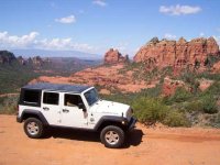
Description: Towering red rock buttes set against a backdrop of deep-green forest and clear blue sky make this road one of Arizona’s most photogenic. The road climbs over 2,200 feet from Sedona to the top of massive Mogollon Rim. Memorable hiking trails depart from several places along the road, and dispersed camping is allowed above Vista Point. The drive is impressive in either direction. Elk may be seen before sunset. Mountain bikers looking for an easy day will enjoy the ride down. If you park, hike, or stop along the route, you’ll need a Red Rocks Pass. Signs recommend only trucks or off-highway vehicles, but cars (not low-slung) can make it in good weather. Although the road is wide and well-maintained, expect a bumpy ride. Much of the lower portion is a shelf road. This road is closed during the winter.
Time & Distance: About 12 miles one way. The road can be driven in an hour but allow much more time, you’ll want to stop many times.
Trail Conditions: Coconino National Forest, Red Rock Ranger District. Call 928 203-7500.
Directions to the Trail:
From the top: Get off I-17 at exit 320 (Schnelby Hill Road) and head west on a short paved road. Bear left on a well marked dirt road at the first turn. We will meet up at 10 AM at the beginning of the dirt road to prep for the ride. Bring some food for lunch and we'll pick a spot along the ride to grab a bite and enjoy the view on the way into Sedona.
Red Rocks Pass information: http://www.fs.usda.gov/detail/coconino/recreation/?cid=stelprdb5416207
Attending:
AZRockJK and 1 guest
piefra
Maybe:
RC3
Location: East of Sedona between Hwy 89A and I-17.
Difficulty: Easy.
Description: Towering red rock buttes set against a backdrop of deep-green forest and clear blue sky make this road one of Arizona’s most photogenic. The road climbs over 2,200 feet from Sedona to the top of massive Mogollon Rim. Memorable hiking trails depart from several places along the road, and dispersed camping is allowed above Vista Point. The drive is impressive in either direction. Elk may be seen before sunset. Mountain bikers looking for an easy day will enjoy the ride down. If you park, hike, or stop along the route, you’ll need a Red Rocks Pass. Signs recommend only trucks or off-highway vehicles, but cars (not low-slung) can make it in good weather. Although the road is wide and well-maintained, expect a bumpy ride. Much of the lower portion is a shelf road. This road is closed during the winter.
Time & Distance: About 12 miles one way. The road can be driven in an hour but allow much more time, you’ll want to stop many times.
Trail Conditions: Coconino National Forest, Red Rock Ranger District. Call 928 203-7500.
Directions to the Trail:
From the top: Get off I-17 at exit 320 (Schnelby Hill Road) and head west on a short paved road. Bear left on a well marked dirt road at the first turn. We will meet up at 10 AM at the beginning of the dirt road to prep for the ride. Bring some food for lunch and we'll pick a spot along the ride to grab a bite and enjoy the view on the way into Sedona.
Red Rocks Pass information: http://www.fs.usda.gov/detail/coconino/recreation/?cid=stelprdb5416207
Attending:
AZRockJK and 1 guest
piefra
Maybe:
RC3
Last edited:
")