You are using an out of date browser. It may not display this or other websites correctly.
You should upgrade or use an alternative browser.
You should upgrade or use an alternative browser.
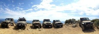
Santiago peak Ca,
- Thread starter Krieger
- Start date


sean.m.adams33
New member
Looks like fun! Thanks for sharing!
Krieger
Member
Santiago peak is a Moderate trail, its easy with some rocky hills to climb
but other than that its just a dirt road
With the exception of some small bypasses to mess around on.
To get to the trail take Highway 74 which is Ortega Highway. From lake Elsinore turn right at 1.2miles past the El Cariso Fire Station. Turn on Long Canyon Road (Not marked, watch for a sign to Los Pinos Camp.)
If you are coming from the 5 freeway up to Ortega turn left 3.2 miles after upper
San Juan Campground.
Once you turn go down the paved road
Turn right at 1.7miles pass Blue Jay Campground. At 2.5. Keep going than turn left on a hidden road at 3.4miles
I tracked the whole trail on the Alltrails App just search the trail and look under
Tracks.
but other than that its just a dirt road
With the exception of some small bypasses to mess around on.
To get to the trail take Highway 74 which is Ortega Highway. From lake Elsinore turn right at 1.2miles
past the El Cariso Fire Station. Turn on Long Canyon Road (Not marked, watch for a sign to Los Pinos Camp.)If you are coming from the 5 freeway up to Ortega turn left 3.2 miles after upper
San Juan Campground.
Once you turn go down the paved road
Turn right at 1.7miles pass Blue Jay Campground. At 2.5. Keep going than turn left on a hidden road at 3.4miles
I tracked the whole trail on the Alltrails App just search the trail and look under
Tracks.
Rivertoys
New member
Hey, I was there!


I ran into you all at the Main Divide / Maple intersection. Nice to meet you guys!
I was on my way back from a run out to Beek's Place...


Lost my CB antenna on that run along Main Divide back. I noticed on my way down to Silverado, but the photo I took where I met you all confirmed it was gone then, so we didn't go back for it.
Jason.
I ran into you all at the Main Divide / Maple intersection. Nice to meet you guys!
I was on my way back from a run out to Beek's Place...
Lost my CB antenna on that run along Main Divide back. I noticed on my way down to Silverado, but the photo I took where I met you all confirmed it was gone then, so we didn't go back for it.
Jason.
Rivertoys
New member
Yeah, The Beek Family owns the land in that area, and still owns the house. They are the family that has run the ferry boat in Newport since the '20s. I did some google searching to find the story behind it, before we went.
Mr Beek bought like 680 acres up there, and was going to subdivide it. He found it was too steep and rugged though. He loved the area and built the house and complex you see in the photos. It was built in the late 30s and very early '40s. I found a date of Sept 1941 in the concrete for the structures that held his wind power generators. They used the house until the mid-1980's. They couldn't keep up with the vandalism though, and stopped trying at that point. The son who is 81 now still goes up there from time to time (he remembers placing the foundation rocks as a kid). He said he thinks his father's spirit is up there somewhere.
Mr Beek bought like 680 acres up there, and was going to subdivide it. He found it was too steep and rugged though. He loved the area and built the house and complex you see in the photos. It was built in the late 30s and very early '40s. I found a date of Sept 1941 in the concrete for the structures that held his wind power generators. They used the house until the mid-1980's. They couldn't keep up with the vandalism though, and stopped trying at that point. The son who is 81 now still goes up there from time to time (he remembers placing the foundation rocks as a kid). He said he thinks his father's spirit is up there somewhere.
mcpuck
Caught the Bug
Very nice! I've been trying to hit this trail for some time but can't find any good info on it. (Where it starts, how to get there's etc) mind filling me in?
Take Chapman Ave east. It turns into Santiago Canyon rd. After you past Irvine Lake turn Left on Silverado Canyon Rd. Take Silverado to the end and keep on going past the fire gate. You are there. You can take it to Santiago Peak and then all the way to Ortega Highway. It’s an easy, scenic day run.
seanb33
-
Hey, I was there!
I ran into you all at the Main Divide / Maple intersection. Nice to meet you guys!
I was on my way back from a run out to Beek's Place...
Lost my CB antenna on that run along Main Divide back. I noticed on my way down to Silverado, but the photo I took where I met you all confirmed it was gone then, so we didn't go back for it.
Jason.
Where are these buildings? I went up today, but didnt see any thing like this
Rivertoys
New member
Where are these buildings? I went up today, but didnt see any thing like this
They are at the north end of Main Divide Road. Where Skyline and Black Star Canyon Rd meet with Main Divide.
33 49.223 N
117 38.313 W
Very near the weather radar station (looks like a big golfball).
gtony12
Caught the Bug
Where are these buildings? I went up today, but didnt see any thing like this
Hey Jason cool pics, sorry about your antenna. I haven't been up there in years need to make s trip up one day.
Sent from my EVO using WAYALIFE mobile app
TNuggs13
Member
Take Chapman Ave east. It turns into Santiago Canyon rd. After you past Irvine Lake turn Left on Silverado Canyon Rd. Take Silverado to the end and keep on going past the fire gate. You are there. You can take it to Santiago Peak and then all the way to Ortega Highway. It’s an easy, scenic day run.
Do you know if you need a forest pass? Also, how long did this take for the day? I think the wife and I are going to make this run this Sunday and wanted to get more info.:thumb:
mcpuck
Caught the Bug
Do you know if you need a forest pass? Also, how long did this take for the day? I think the wife and I are going to make this run this Sunday and wanted to get more info.:thumb:
I think technically yes you need a pass if you are parked somewhere. Just don’t park anywhere for too long. I’ve never been asked to show one.
seanb33
-
Do you know if you need a forest pass? Also, how long did this take for the day? I think the wife and I are going to make this run this Sunday and wanted to get more info.:thumb:
As long as you do not park and leave your jeep, you should be fine but in the 3+ times I have been there, I have never seen a ranger or anybody of authority. You can also enter the trail from the Ortega highway or the Indian truck trail off the 15. If you speed through it, you can be up and back down within 2 hours but if you take your time, it can take 3+ hours. If you can, I'd suggest being at the top for sunset as it's quite the view on most nights

TNuggs13
Member
I think technically yes you need a pass if you are parked somewhere. Just don’t park anywhere for too long. I’ve never been asked to show one.
Cool. Good to know. Not planning on parking to hike.
TNuggs13
Member
As long as you do not park and leave your jeep, you should be fine but in the 3+ times I have been there, I have never seen a ranger or anybody of authority. You can also enter the trail from the Ortega highway or the Indian truck trail off the 15. If you speed through it, you can be up and back down within 2 hours but if you take your time, it can take 3+ hours. If you can, I'd suggest being at the top for sunset as it's quite the view on most nights
Thanks. Those are the 2 ways I saw on how to get up there. Thinking of entering off Santiago Rd and ending on the 74.