You are using an out of date browser. It may not display this or other websites correctly.
You should upgrade or use an alternative browser.
You should upgrade or use an alternative browser.
Mammoth Lakes Trails?
- Thread starter jkjurny
- Start date


Rebel JK
New member
Are you very familiar with mammoth/ june area already? There are miles of trails and loops between them. We were there a few weeks and put in almost 100 miles in on trails in the area exploring. Of course we did Laurel lakes, but down in the valley, we also found an interesting water harvesting system set up on a creek in a box canyon where we went down to bust a few clays with the 12 gauge. Hmmm...
Last edited:
jkjurny
Member
Are you very familiar with mammoth/ june area already?
No. This is my first time there. Going with the family camping. Wheeling will be an activity for maybe 5 hours on Saturday.
Rebel JK
New member
What area are you camping at? If you are down in sherwin creek area then laurel lakes trail head is just south a few miles. The views up there are straight out of an Ansel Adams photo shoot. You may want to bring some fishing gear with you on this one for the lakes. Actually if you like to fish, you want to carry your gear with you full time up there!!
If your up around twin lakes or lake mary then you may want to hit the inyo craters area off the scenic loop drive which takes you up towards deadmans creek where there are miles of easy 4low volcanic sand with scenic areas and creek crossings in and out of the trees. You can figure out different loops which can take you back to the scenic road or all the way back down into the town of mammoth.
Surprisingly, We hardly saw anyone on the trails out there late June so it was really nice.
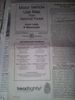
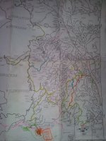
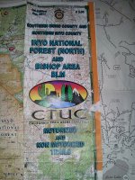
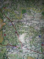
We have been going to mammoth for many years but only a couple times with the jeep so I have a lot of exploring yet to do. Your best bet is to stop by the visiter center when you get into town and pick up the latest four wheeling/ offroad maps. You should ask for the 2 free maps because neither one show all the trails, but between the 2 you can get around pretty well and avoid getting lost.
My last 2cents are to make sure to hit mammoth brewery and pick up some epic IPA's!! We also used to pick up a growler of root beer for the kids when they were younger. Shoot me a pm and I can shoot you over a pic of the maps I've got. I can't get my wol app to sinc with my iPad for pics.
If your up around twin lakes or lake mary then you may want to hit the inyo craters area off the scenic loop drive which takes you up towards deadmans creek where there are miles of easy 4low volcanic sand with scenic areas and creek crossings in and out of the trees. You can figure out different loops which can take you back to the scenic road or all the way back down into the town of mammoth.
Surprisingly, We hardly saw anyone on the trails out there late June so it was really nice.
We have been going to mammoth for many years but only a couple times with the jeep so I have a lot of exploring yet to do. Your best bet is to stop by the visiter center when you get into town and pick up the latest four wheeling/ offroad maps. You should ask for the 2 free maps because neither one show all the trails, but between the 2 you can get around pretty well and avoid getting lost.
My last 2cents are to make sure to hit mammoth brewery and pick up some epic IPA's!! We also used to pick up a growler of root beer for the kids when they were younger. Shoot me a pm and I can shoot you over a pic of the maps I've got. I can't get my wol app to sinc with my iPad for pics.
jkjurny
Member
What area are you camping at? If you are down in sherwin creek area then laurel lakes trail head is just south a few miles. The views up there are straight out of an Ansel Adams photo shoot. You may want to bring some fishing gear with you on this one for the lakes. Actually if you like to fish, you want to carry your gear with you full time up there!!
If your up around twin lakes or lake mary then you may want to hit the inyo craters area off the scenic loop drive which takes you up towards deadmans creek where there are miles of easy 4low volcanic sand with scenic areas and creek crossings in and out of the trees. You can figure out different loops which can take you back to the scenic road or all the way back down into the town of mammoth.
Surprisingly, We hardly saw anyone on the trails out there late June so it was really nice.
We have been going to mammoth for many years but only a couple times with the jeep so I have a lot of exploring yet to do. Your best bet is to stop by the visiter center when you get into town and pick up the latest four wheeling/ offroad maps. You should ask for the 2 free maps because neither one show all the trails, but between the 2 you can get around pretty well and avoid getting lost.
My last 2cents are to make sure to hit mammoth brewery and pick up some epic IPA's!! We also used to pick up a growler of root beer for the kids when they were younger. Shoot me a pm and I can shoot you over a pic of the maps I've got. I can't get my wol app to sinc with my iPad for pics.
We're near Lake Mary. Thanks for the tips, especially about the brewery! I think we'll do Inyo Craters. I'd love to do Laurel Lakes, but the group I'm with may not want to deal with the shelf road. We'll see. Thanks again!
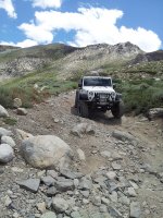
You gotta do Laurel Canyon. It is on the cover of the Sierra Nevada byways trail book and is an awesome trail that goes to the top of the mountain SE of Mammoth a few miles.
View attachment 40296
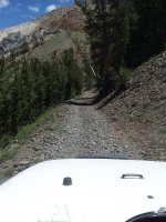
Trail looks narrow like its a quad trail, how wide was it?
Wouldn't be fun meeting someone coming the other way!
Rebel JK
New member
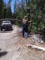
Here are the maps I picked up. I usually carry an axe too just in case of any dead low hangers like this one. Keep it right next to the good old 870.
Attachments
Rebel JK
New member
Trail looks narrow like its a quad trail, how wide was it?
Wouldn't be fun meeting someone coming the other way! .
There are a few sections a little more narrow than this and it's a long ways down. The bottom half is plenty wide though.
Wouldn't be fun meeting someone coming the other way! .
There are a few sections a little more narrow than this and it's a long ways down. The bottom half is plenty wide though.