Northern Sacramento area trails?

Rccrwlr

New member
Looking to find some mild trails in the Northern Sac area ( Nevada City, Grass Valley, Forest Hill, even out to Oroville). Any suggestions? Thinking about the high lakes outside of Chico but that may be a bit far for a quick trip. Looking to take a couple of families with rigs out for the day.


1979 Jeep CJ5 - rccrwlr
2008 Jeep JKUR - pheartmtngot
 

wayoflife

Administrator
Staff member
Looking to find some mild trails in the Northern Sac area ( Nevada City, Grass Valley, Forest Hill, even out to Oroville). Any suggestions? Thinking about the high lakes outside of Chico but that may be a bit far for a quick trip. Looking to take a couple of families with rigs out for the day.


1979 Jeep CJ5 - rccrwlr
2008 Jeep JKUR - pheartmtngot
Depending on how far you want to drive, I would head up to Downieville and do a run up to Poker Flat. Nice mild trail with a lot of history and scenery.
 

Rccrwlr

New member
Have been looking at Signal
Peak. It keeps coming up when I poke around. Anyone been up there?


1979 Jeep CJ5 - rccrwlr
2008 Jeep JKUR - pheartmtngot
 

OverlanderJK

Resident Smartass
Thanks for being so specific! When i drive up to the Sierras should i take the left or right trail? :)


1979 Jeep CJ5 - rccrwlr
2008 Jeep JKUR - pheartmtngot
:cheesy:

I was at work sorry for the short response. I figured it would give you some place to search. :thumb:
 
Looking to find some mild trails in the Northern Sac area ( Nevada City, Grass Valley, Forest Hill, even out to Oroville). Any suggestions? Thinking about the high lakes outside of Chico but that may be a bit far for a quick trip. Looking to take a couple of families with rigs out for the day.


1979 Jeep CJ5 - rccrwlr
2008 Jeep JKUR - pheartmtngot
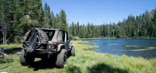
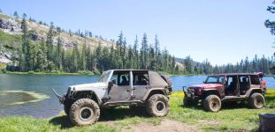
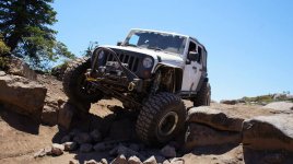
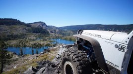
High Lakes are great! If you are heading up there let me know I live in Chico and could meet ya. Here are a couple pics from up there.

Camping spot on Long Lake:
969630_10201142300813896_1731199965_n.jpg

Top of Stair Step:
1003974_10200738845567767_882017713_n.jpg

Above Morris Lake by the mine:
1044316_10200865161125577_75943226_n.jpg

Another angle of Long Lake:
1170879_10201142299413861_1907459006_n.jpg
 

Rccrwlr

New member
High Lakes are great! If you are heading up there let me know I live in Chico and could meet ya. Here are a couple pics from up there.

Camping spot on Long Lake:
View attachment 45761

Top of Stair Step:
View attachment 45762

Above Morris Lake by the mine:
View attachment 45763

Another angle of Long Lake:
View attachment 45764

Sounds good. Been a long time since I was up there (since '97 when I graduated). I will look you up if we decide to go. Let me know if you plan a trip as well.


1979 Jeep CJ5 - rccrwlr
2008 Jeep JKUR - pheartmtngot
 
Sounds good. Been a long time since I was up there (since '97 when I graduated). I will look you up if we decide to go. Let me know if you plan a trip as well.


1979 Jeep CJ5 - rccrwlr
2008 Jeep JKUR - pheartmtngot

I usually go at the drop of a hat but if we plan something I will shoot ya a message.
 

wayoflife

Administrator
Staff member
Have been looking at Signal Peak. It keeps coming up when I poke around. Anyone been up there?

Depending on how built up your Jeep is, it can be more difficult than mild but, a nice trail just the same with great views from the top.

High Lakes are great! If you are heading up there let me know I live in Chico and could meet ya. Here are a couple pics from up there.

Camping spot on Long Lake:
View attachment 45761

Top of Stair Step:
View attachment 45762

Above Morris Lake by the mine:
View attachment 45763

Another angle of Long Lake:
View attachment 45764

Awesome shots!! Being that my mom lives in Chico, I've been meaning to check out the area for a long time now and will have do get er done sooner than later.
 
Signal peak is good for a day trip but with the American fire so close its not worth doing until the fire is out. The main attraction is view and with the smoke you won't be able to see that far.
 

spinuck

New member
Have been looking at Signal
Peak. It keeps coming up when I poke around. Anyone been up there?


1979 Jeep CJ5 - rccrwlr
2008 Jeep JKUR - pheartmtngot

Get off at Cisco Grove exit, you can get up there easily following forestry roads, turn left just before Fordyce lake. If you get off at Eagle Lakes exit, there are some small river crossings and swimming holes that are nice and some other dirt roads. If you go up Carlye Road ( at least that what it's called on google maps), it gets fun and challenging, but proceed at your own risk.

I've been to forresthill area, most just forestry roads and motorcycle trails from what i saw. I did find a nice rocky descent that lead down to the river and some old mining operation which was cool.

There are a lot trails near downieville as has been mentioned, check out gold lake area.

have fun.
 
Last edited:

Rccrwlr

New member
Signal peak is good for a day trip but with the American fire so close its not worth doing until the fire is out. The main attraction is view and with the smoke you won't be able to see that far.

Thanks for the heads up.


1979 Jeep CJ5 - rccrwlr
2008 Jeep JKUR - pheartmtngot
 

Rccrwlr

New member
Get off at Cisco Grove exit, you can get up there easily following forestry roads, turn left just before Fordyce lake. If you get off at Eagle Lakes exit, there are some small river crossings and swimming holes that are nice and some other dirt roads. If you go up Carlye Road ( at least that what it's called on google maps), it gets fun and challenging, but proceed at your own risk.

I've been to forresthill area, most just forestry roads and motorcycle trails from what i saw. I did find a nice rocky decent that lead down to the river and some old mining operation which was cool.

There are a lot trails near downieville as has been mentioned, check out gold lake area.

have fun.

Thanks for the details. Going to wait until the fire is out. Trying to organize a Poker Flat run. Have to work out the date first.


1979 Jeep CJ5 - rccrwlr
2008 Jeep JKUR - pheartmtngot
 
Top Bottom