In Dash GPS for Wrangler JK.....

JS-CHLLN

New member
I've looked and cant seem to find if there is a thread for what I am asking but if there is could anyone please direct me. Thank You in Advance. My question..... Is there an in dash audio that has GPS locations for trails?? ie. If you are in South Carolina it would be able to pull up the GPS for all trails in the area you are located? Or is there a Handheld device that offer it?

Thank You
 

mo0s3

New member
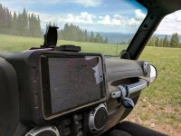
I use Gaia gps on my I pad with a custom mount I made for this reason. It works offlne and maps all trails including pictures and notes.


Sent from my iPhone using WAYALIFE mobile app
 

JS-CHLLN

New member
Unfortunately I have Droid and the reviews for the Droid version I'm not feeling or trusting, Will have to keep searching. Thanks for the info!
 

TRLJNKY

New member
Unfortunately I have Droid and the reviews for the Droid version I'm not feeling or trusting, Will have to keep searching. Thanks for the info!
I use the hell out of the Gaia app on my S7. No issues. Download maps offline, preload routes, share routes, etc. Not sure what the reviews state but for $20 its legit

Edit: I forgot to mention I stopped using my in dash nav all together. Using my phone is so much easier to use than trying to mess with the head unit. I also have a custom mount for my phone

It's half past f'it with the CAPS lock on!
 
Last edited:

mo0s3

New member
I use the hell out of the Gaia app on my S7. No issues. Download maps offline, preload routes, share routes, etc. Not sure what the reviews state but for $20 its legit

Edit: I forgot to mention I stopped using my in dash nav all together. Using my phone is so much easier to use than trying to mess with the head unit. I also have a custom mount for my phone

It's half past f'it with the CAPS lock on!

This [emoji115]


Sent from my iPhone using WAYALIFE mobile app
 

BobNH

Member
If your area/state has released the interactive gps maps of all class roads (.tiff files I think?), then you can pay (now, grrrr) for a sub to Avenza maps app for your phone/tab and download the maps to your device. Android and iOS.

Sent from my SM-N910V using WAYALIFE mobile app
 

Tanktitan

Member
I've looked and cant seem to find if there is a thread for what I am asking but if there is could anyone please direct me. Thank You in Advance. My question..... Is there an in dash audio that has GPS locations for trails?? ie. If you are in South Carolina it would be able to pull up the GPS for all trails in the area you are located? Or is there a Handheld device that offer it?

Thank You

Don't mess with a head unit. Get the Carrich iPad mount:

https://www.carrichs.com/product/tdk616/

Ask for the WAYALIFE discount, they may still honor it. I think the offer was $75.

Then get a mini iPad and Gaia app. You can download blocks of data for the areas you run. That way you are not dependent upon being in cell coverage. If you want real pinpoint accuracy of where you are, get an external GPS like a Dual, again so you are not reliant on cell towers triangulating where you are.


Sent from my iPhone using WAYALIFE mobile app
 

JS-CHLLN

New member
Thanks for all the advice, I think I will try the Gaia on my S7 and see what happens. the 20.00 spend isn't bad at all. I spend that on a drink down here in Miami!! Thanks again everyone!
 

Speedy_RCW

Hooked
Thanks for all the advice, I think I will try the Gaia on my S7 and see what happens. the 20.00 spend isn't bad at all. I spend that on a drink down here in Miami!! Thanks again everyone!

I use the Gaia app too and highly recommend it. I was hesitant about spending the $20 if the app sucked. I called them up and they said if I didn't like the app, they'd refund the $20 so there's always that avenue if you don't like it.


Sent from my iPhone using WAYALIFE mobile app
 

Tanktitan

Member
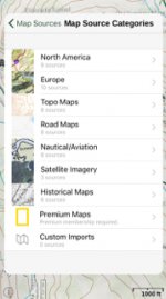
For Gaia users, they recently added some new maps under the premium section, accessed from this screen:

IMG_2913.JPG

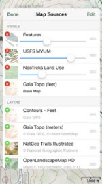
They now have Forest Service MVUM's and some other maps to show greater detail around you. Here is a configuration I have used:

IMG_2911.JPG

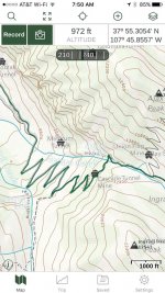
And what it looks like as displayed (this is Black Bear Pass switchbacks:

IMG_2912.jpg


Sent from my iPhone using WAYALIFE mobile app
 
Top Bottom