Jsouder53
Hooked
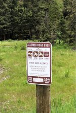
I’m new to exploring forest service roads and came across this sign a couple times. Was kinda confused to what it means. I see it says open from June 16 to December 1 but then also a line through an image of a Jeep. There was an open gate as well with tire tracks going up the trail... I wasn’t sure whether or not we were allowed to go on, so we turned back...
Sent from my iPhone using WAYALIFE mobile app
 I see it says open from June 16 to December 1 but then also a line through an image of a Jeep. There was an open gate as well with tire tracks going up the trail... I wasn’t sure whether or not we were allowed to go on, so we turned back...
 Sent from my iPhone using WAYALIFE mobile app
