2014 WAYALIFE Death Valley Adventure Photo Highlights

wayoflife

Administrator
Staff member
Thanksgiving weekend has always been a time where Cindy and I have taken a trip out to Death Valley and done some exploring. In fact, we had been doing this for years by ourselves and more recently, with all our WAYALIFE friends. For 2014, we decided to begin our adventures in the town of Ridgecrest, CA, and spend our Black Friday working our way over the Slate Range, through the historic Fish Canyon, across the floor of the Panamint Valley, up Goler Wash into the Butte Valley, down into Death Valley and then finally end our day in Shoshone, CA. On Saturday, we headed back into Death Valley to enjoy some of the tourist traps like Ashford Mill, Bad Water, the Devils Golf Course and then worked our way up and over the Funeral Range through Echo Canyon and ended our day in Beatty, NV. For our final day on this epic three day adventure, we paid a visit to the historic ghost town of Rhyolite, headed back into Death Valley through Titus Canyon and then made our way back to Highway 395 where we all said our goodbyes and went our separate ways. Below is a photo narrative of all the things we had seen and done and I hope you enjoy them.

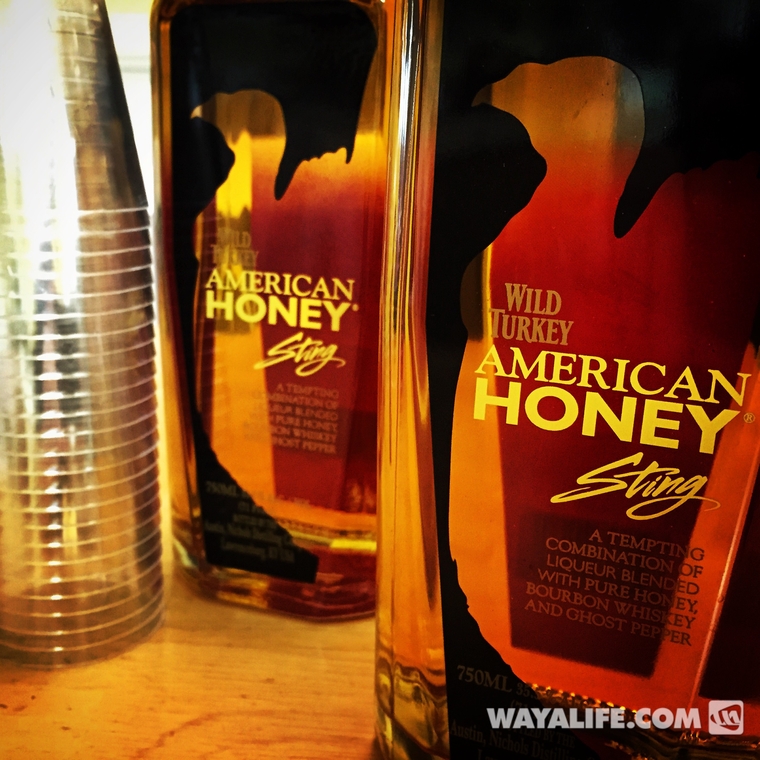
As everyone knows, we always come prepared with a little American Honey and for 2014, we decided to bring something new - Honey Sting!
main.php


Here's a shot of Moby with his new Truck-Lite LED headlights and Rugged Ridge half doors all packed, shiny and clean and ready to head south to get all dirty.
main.php


The first of many - thank goodness gas prices are finally starting to come down a bit!
main.php


Getting ready to go behind enemy lines.
main.php


Hello California!
main.php


Paying a visit to the Iron Maiden and friends.
main.php


main.php


"To give and then take or to take without giving?" That is the question.
main.php


Home for the night.
main.php


Day 1
The first official day of our 2014 WAYALIFE Death Valley Thanksgiving Weekend Adventure would be what most refer to as, Black Friday. Because we would be crossing into Death Valley from the southern end of the Panamint Range, we decided to meet everyone who would be joining us in Ridgecrest. Here shot of everyone joining us for the run all packed up and ready to go.
main.php


At the trailhead airing down and getting ready to have some fun.
main.php


Climbing the Slate Range.
main.php


Along the ridge of the Slate Range taking in the awesome view of the Panamint Valley below.
main.php


Descending into Fish Canyon as we make our way down into the Panamint Valley.
main.php


main.php


main.php


main.php


Back in 1850, the Bennett and Arcanes, two families trying to emigrate to California decided to take a route that lead them through Death Valley. Along the way, they had to abandon their wagon and needed to be rescued. It was at this point in Fish Canyon, named after a Father Fish who perished here a few days before, where Manley and Rogers came to the families in need and led them to safety.
main.php


main.php


main.php


View from the valley floor looking at our train of Jeeps slowly working their way down the very rough and bumpy alluvial fan of Fish Canyon. It's hard to imagine how anyone could have done this in a wagon. In fact, it this stretch of trail is so rough that back in the 1800's, settlers would fashion makeshift shoes out of leather to help protect the hoofs of their oxen.
main.php


Regrouping and getting ready to move out again.
main.php


Heading south along the eastern shores of the ancient Panamint Dry Lake.
main.php


Making a stop at the mouth of Goler Wash to take it all in.
main.php


main.php


Time to head on up the canyon.
main.php


main.php


main.php


main.php


main.php


main.php


Making a stop to check out the ruins of the Keystone Mine which is located next to Lotus Springs. It hard to imagine but this camp was occupied and the mines in the area worked on until 1997 when it was finally abandoned.
main.php


main.php


main.php


main.php


main.php


main.php


main.php


If you're going to have to work in a place like Death Valley, having a swimming pool would make life a bit easier. Chris and Jen heading up to it take a closer look.
main.php


main.php


Jen getting ready to dive in.
main.php


Time to load up and head on out again.
main.php


Further up Goler Wash, we finally reach the Death Valley National Park boundary line.
main.php


Before continuing into Death Valley, we took a detour to pay a visit to the Barker Ranch site.
main.php


Years ago, there used to be a large branch here that arched over the trail and made it difficult if not impossible for tall rigs to continue forward. As you can see, it has long since been chopped off.
main.php


Here we are at Barker Ranch.
main.php


Back in 1969, CHP and Inyo Sherriff came up to this location to look for people responsible for vandalizing some earth movers and by chance, discovered Charles Manson hiding out in a tiny bathroom cabinet. For years, this was an amazing ranch to visit with irrigated fruit trees and a beautiful and well preserved ranch house complete with a lattice covered porch. Sadly, this house was burned down by vandals in 2008.
main.php


main.php


main.php


This is all that remains of this once amazing home in the middle of the desert.
main.php


main.php


main.php


main.php


main.php


main.php


main.php


main.php


main.php


main.php


main.php


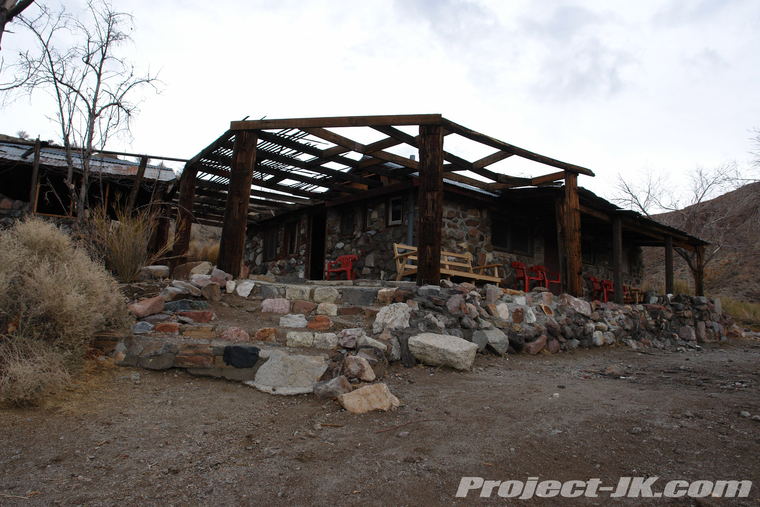
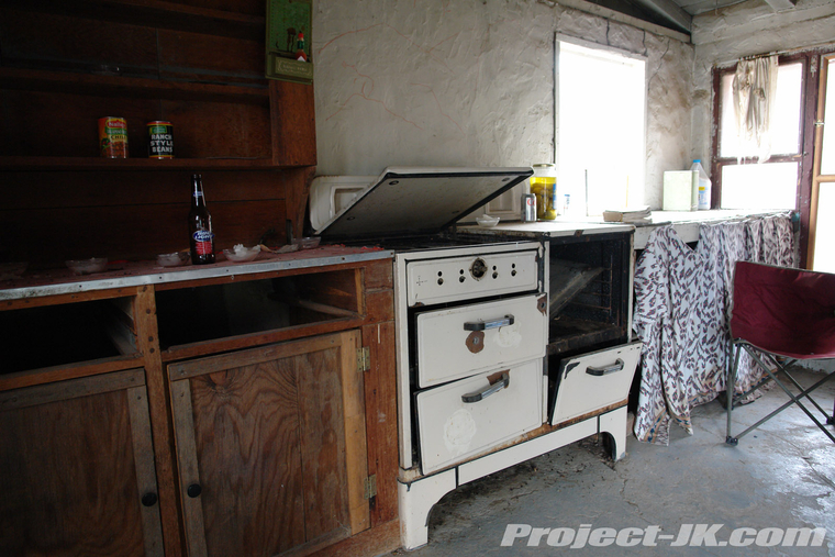
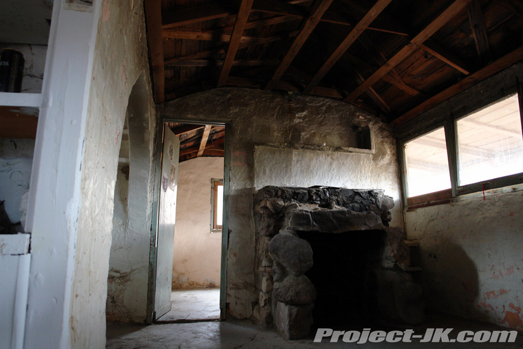
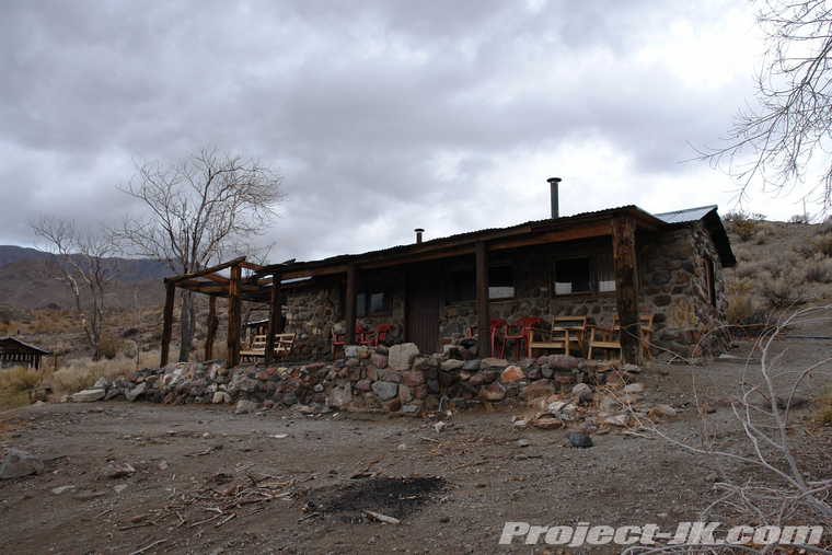
For those of you who never got a chance to see what it looked like before, here are a few shots that we took of Barker Ranch before it was burned down in 2008.
main.php


main.php


main.php


main.php


More photos below...
 

wayoflife

Administrator
Staff member
After our nice visit to the old Barker Ranch site (aka, Charles Manson house) and a well needed lunch stop, we were back on the road again and on our way up to Mengel Pass.
main.php


main.php


main.php


Heading up to the top of the observation point at Mengel Pass.
main.php


Moby pulling up to the edge to get a good look at the Striped Butte.
main.php


Everyone else making their way up.
main.php


main.php


Stephanie getting a little flexy toward the top.
main.php


Chris too.
main.php


Louie getting a little hang time in.
main.php


Joshua in the same boat.
main.php


As well as Ray.
main.php


Brendon saying "ruts - what ruts?"
main.php


Wagons circled and time to take in the view.
main.php


I don't know if it's true or not but, from what I have read, the Striped Butte you see in the distance is a billion year old piece of ocean sediment thrusting through the valley floor.
main.php


Time to move on out and check out our next destination in the Butte Valley.
main.php


main.php


Our next stop was over at what most people refer to as the "Geologist Cabin". Back in the day, this stone house overlooking the Striped Butte and the Butte Valley beyond was the home of Carl Mengel, the prospector who worked the surrounding area and who the pass we just crossed over is named after.
main.php


Stephanie excited to find some bloody Mary mix inside.
main.php


main.php


main.php


main.php


main.php


main.php


Closer view of the Striped Butte.
main.php


Another shot with a family of burros posing for a shot.
main.php


On the move again and working our way across the Butte Valley.
main.php


main.php


After pulling into Warm Springs, we got a call on the radio that Louie blew a tire but that it was getting worked on and so, we decided to hang out here till they caught up.
main.php


Before Warm Spring was a talc mine operated by the Pfizer Corporation and worked until the 1980's, gold was mined in the area and some of the equipment used to process the ore can still be found nearby. While we were waiting for the rest of our group, we decided to check it out.
main.php


main.php


main.php


As we would later find out, after Louie got his tire changed, he ended up blowing out another just down the way. Fortunately, Rachel and Ray had a stock spare and they loaned theirs to him. Here's a shot of everyone pulling into Warm Springs.
main.php


A closer look at the sidewall damage.
main.php


All back together again, it was time to do some exploring.
main.php


About 20 years ago, Cindy and I had visited this place and at the time, it was still in much better shape with an awesome "warm spring" fed pool that was perfect for diving into. Well, I suppose time has a way of changing things as the pool didn't look to inviting on this day.
main.php


One of the many mustard colored buildings or, dormitories located at the mining camp.
main.php


Shot from the inside.
main.php


Clearly, this place has seen better days.
main.php


Meat locker right out of a horror flick.
main.php


Back on the trail and heading down into Death Valley.
main.php


main.php


main.php


main.php


Regrouping on the valley floor.
main.php


After a long day out on the trail, it was time for a hot meal and drinks over at the Crowbar Café & Saloon.
main.php


Oh, and did I mention it was Joshua's 30th birthday - HAPPY BIRTHDAY!!
main.php


CHEERS!!
main.php


Of course, what would a WAYALIFE trip be without a nightcap. Good times with good friends all around a nice fire - CHEERS!!
main.php


More photos below...
 

wayoflife

Administrator
Staff member
Day 2
Good morning from Shoshone, CA - time to gas up!!
main.php


Unfortunately, Tony, Stephanie, their daughter Christina, Et and his son Joe all had to leave us the night before but, we were joined by Al, Jason, Amy, their two kids, Naomi, Russell, Simo and Vanessa. Here's a shot of our Jeeps over at Ashford Mill, our first stop of the day.
main.php


main.php


main.php


Back in 1914, gold ore from the Golden Treasure Mine was processed here.
main.php


main.php


main.php


main.php


main.php


Back on the road and heading north up the valley floor.
main.php


main.php


The most famous destination in the entire Death Valley National Park is without question, Badwater Basin. Located along the eastern shores of the ancient Manley dry lake and pretty much in the center of the park, Badwater Basin sits at 282 feet below sea level and is the lowest point in North America.
main.php


There is a small spring-fed pool of "bad" water that exists here year round and amazingly enough, it does contain some plant life like the pickleweed and even a few aquatic insects and the Badwater snail.
main.php


Beyond the pool, the salt flat is rough from repeated freezing, thawing and evaporation.
main.php


Taking a hike out into the salt flat.
main.php


Of course, what would a trip to Badwater Basin be without tasting the salt. Here's a shot of Chris taking a taste.
main.php


main.php


Trying to persuade Jason to do it.
main.php


Deciding not to wait for him to do it, Amy jumps right in to give it a try.
main.php


main.php


Our next stop was over to the Devil's Golf Course which was just up the way.
main.php


Stepping out on to "the green" to check things out.
main.php


Back in 1934, a comment in a Death Valley National Monument National Park Service guide stated that the halite salt crystal formations in this area was so rough that "only a devil could play golf" on its surface. Speaking of which, look what we found here.
main.php


A few shots of the jagged surface.
main.php


main.php


main.php


Some of the bizarre salt formations.
main.php


main.php


After our fun on the valley floor, we headed to the base of the Funeral Range to get ready to make our way out of it via Echo Canyon. Here we are getting the newcomers in our group aired down.
main.php


main.php


And we're off!
main.php


main.php


Up the canyon we go.
main.php


main.php


The canyon walls getting real pretty.
main.php


Coming up on the "Eye of the Needle".
main.php


On the back side of the Eye posing for a few shots.
main.php


main.php


main.php


More photos below...
 

wayoflife

Administrator
Staff member
On the move again and on our way to the Inyo Mine.
main.php


At the Inyo Mine and our lunch stop for the day.
main.php


main.php


Decided to go for a hike up the hill.
main.php


Looking back at the mining camp below.
main.php


main.php


main.php


Jen taking a spin in an old mining rig.
main.php


Gold was discovered here by Maroni Hicks and Chet Leavitt back in 1905 and the mines in this area were worked on and off until about 1941 by a myriad of investors including Charles Schwab. Unfortunately, a string of bad timing and poor results lead to the early demise of the mine. However, the claim is still privately owned and some of the tunnels can still be explored today. NOTE: These mines are very dangerous and have vertical shafts that appear out of nowhere.
main.php


main.php


main.php


main.php


Looking up one of the vertical shafts.
main.php


Back outside carefully taking a peek down.
main.php


main.php


View looking back at our Jeeps way out in the distance.
main.php


On the move again and heading for the only real obstacle on the trail.
main.php


After watching and helping a JK and a 4Runner ahead of us up the rock ledges, everyone headed back to their Jeeps and got ready to make the climb themselves.
main.php


Moby walking up the ledges with ease.
main.php


Chris coming up the first ledge.
main.php


Jason following closely behind.
main.php


Louie doing a great job in his stock JK.
main.php


Russell working his way up the second ledge.
main.php


Ray starting his climb.
main.php


Brendon wondering where the obstacle is.
main.php


Al starting is ascent.
main.php


Just a walk in the park for Joshua.
main.php


Beautiful views as we worked our way around some narrow shelf roads.
main.php


main.php


main.php


main.php


I don't know how it was possible but, coming around the shelf roads, Louie blew out two more tires.
main.php


main.php


Time to get to work and swap one out and with any luck, plug the other.
main.php


main.php


main.php


Time to reseat the bead and hope for the best.
main.php


So far so good.
main.php


Let's wrap it up and get going again.
main.php


Hard to imagine that one guy can get four flats on one easy run but...
main.php


And just like that, we're doing a night run.
main.php


main.php


main.php


main.php


All safe and sound in Beatty, NV - CHEERS to a great day on the trail!!
main.php


But wait, what's this? Looks like a WAYALIFE good time - CHEERS AGAIN!!
main.php


main.php


More photos below...
 

wayoflife

Administrator
Staff member
Day 3 - Journey Home
Good morning! Our final day on the 2014 WAYALIFE Death Valley Thanksgiving Adventure got started in the town of Beatty, NV. Originally home to the Western Shoshone people, Beatty was established in 1905 and named after a rancher by the name of Montillus (Montillion) Murray "Old Man" Beatty, a rancher who also became the first postmaster of Beatty.
main.php


Checking out some of the fine soda selections at Eddie World.
main.php


main.php


main.php


After gassing up at Eddie World, we made our way over to our first stop along our route home, Rhyolite.
main.php


Founded in 1905, Rhyolite was one of several mining camps that formed during a gold rush during that time and became a preferred settlement due to its sheltered basin close to the Montgomery Shoshone Mine, one the largest producers in the area. Thanks to Charles Schwab, the town was quickly developed to include plumbing, electricity, a railroad, telephone service, a newspaper, school, hospital, opera house and even a stock exchange. At it's height, the town saw a population of about 5,000 people in 1907-08. Unfortunately, Rhyolite disappeared about as quickly as it appeared thanks to the financial panic of 1907. By the end of 1910, the Montgomery Shoshone Mine was operating at a loss and eventually closed by 1911. By 1920, the population of Rhyolite was essentially zero.

Here are some shots of the famous bottle house that was restored and still stands there today.
main.php


main.php


main.php


Ghost crickets permanently entombed within one of the many bottles that make up this house.
main.php


Downtown Rhyolite checking out some of the old building barely still standing.
main.php


What's left of the Cook Bank Building.
main.php


main.php


main.php


All that's left of the old two story eight room school house.
main.php


main.php


The railroad station had a longer life than the town as it became a casino in 1937 called the Rhyolite Ghost Casino. It was later turned into a museum and gift shop that operated until the 1970's. It's a shame that it's all fenced off now.
main.php


main.php


main.php


main.php


Toward the south end of town, a series of sculptures were made by the Belgian artist Albert Szukalski in 1984 and are now part of the Goldwell Open Air Museum.
main.php


On the move again and on our way to our next destination along our trip home - Titus Canyon.
main.php


main.php


main.php


main.php


Really? A BMW??
main.php


main.php


Making our way up to Red Pass.
main.php


main.php


main.php


main.php


Up and over Red Pass and heading down into Titus Canyon.
main.php


main.php


main.php


Making a stop in the Leadfield, a boomtown that was established in August 1926 based on wild advertising and was nothing more than a ghost town by February 1927.
main.php


main.php


main.php


main.php


main.php


Time to head into Titus Canyon.
main.php


main.php


main.php


Titus Canyon cuts through the Grapevine Mountains and while they were created relatively recently, the rocks that make up the range are over half a billion years old. The gray limestone rocks that you see in this section of Titus Canyon are from the Cambrian age which is 570-505 million years old.
main.php


main.php


main.php


Out of the canyon and time to air up again.
main.php


On our way back to Highway 395, we made a quick stop over at the Father Crowley Viewpoint to take a final group shot.
main.php


main.php


Hooray to an awesome WAYALIFE adventure!!
main.php


A BIG thanks needs to go out to everyone who joined us on this trip. Cindy and I had a great time with all of you and hope that you'll join us again on future WAYALIFE adventures. :cool:

To see more great photos from our 2014 WAYALIFE Death Valley Thanksgiving Adventure, simply click on the link below:
2014 WAYALIFE Death Valley Thanksgiving On the Go Photo Thread!!
 

tuna

New member
Amazing pictures! I was there a week before thanksgiving but didn't get to do any real offroading or exploring like you guys. That Devil's golf course is no joke - It's the kind of place you leave a man with no shoes and a gun with one bullet to think over his sins :dont_tell:
 

JAGS

Hooked
Awesome pics for an awesome trip. Was great to see some old friends and the chance to wheel with some new ones. My whole family had a great time!! Hopefully we can make it out for years to come.

A big thanks to Eddie and Cindy for organizing such a great trip that didn't leave a boring moment the entire time.

Jason (and Amy and kids)
 

Wizard

New member
Bravo! :clap2:

What a great trip report. Brilliant photos, and all the history to go with it. :thumb:
 
Top Bottom