Directions to the High Lakes
Here are directions to the High Lakes. This only gives directions to the first lake, Spring Valley. There is a huge area to play and wheel and explore out there so do your research ahead of time. Please remember pack out what you pack in and if you see any garbage someone left please pack it out too.
All the mileage is based on Google maps not my actual vehicle due to variances on all vehicles. Roughly 50 miles total. If you have any questions please let me know and I will make the directions clearer. Thanks.
1. Staring Location (Reset your odometer here): Chevron, 2501 Notre Dame Boulevard, Chico, CA 95928
2. Drive 11.2 miles up Skyway to the town of Paradise. Skyway is 55 mph and a massive speed trap. Speed at your own risk.

3. From Paradise continue on Skyway. At 18.8 miles you will see Chucks Place gas station on your right hand side. You will now be in Magalia and this is one of your last places to get fuel and snacks for the road.
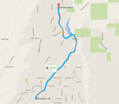
4. Exit Chucks Place to the right and continue up Skyway. At 28.3 miles you will be entering a small town called Stirling City. The speed limit is 25 mph…I HIGHLY RECOMMEND you follow this speed limit.
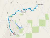
5. After leaving Stirling City you will be on a two lane, yes two lane I know it doesn’t look like it, road. This will take you to InSkip. At 34.5 miles you should see an old building on your right that used to be a hotel and a bunch of tractors and storage containers. This is InSkip.
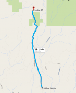
6. After leaving InSkip the road will widen up and feel a bit more normal. Continue on this road until you reach 38.1 miles. You will see what looks to be a Y ahead of you (left side will be paved, right side will be dirt/gravel) and a spot to pull off on the right hand side. Go ahead and pull off the road this is where you will air down.
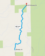
7. After airing down head right onto the dirt road. The dirt road will only last a short while. At 39.4 miles you will get to a paved road. You should see a sign that says High Lakes, Philbrook Lake and Lake Almanor. Turn right onto the paved road.
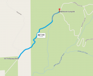
8. Once on the paved road keep going. This will only be a couple miles long before you will hit dirt again. You will cross a small one-lane bridge and make a right turn up the hill. At the top of this hill is a big swooping left hand turn SLOW DOWN it catches people off guard and being aired down will not help. Once you are back on the dirt road and reach 43.1 miles you will be in a big clearing that Y’s off. This is the turn for Philbrook Lake. Go left up the hill.
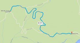
9. After turning left up the hill away from Philbrook Lake keep following this road. At 44.9 miles you will reach a swooping right hand turn but there will also be a Y here. Keep on the main road to the right. If the logging area up the hill is on your right (passenger side) you went the wrong way.
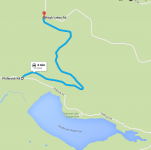
10. Continue on this main road. At 47 miles you will come to another Y, veer to the right down the hill, this will be the better-looking road. Do not go left you will find unhappy people there and you will not be welcome.
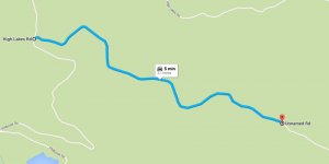
11. After veering right at the Y, continue on this road. Next is “T-Line” also known as “The Fire Camp”. You will be at 49.3 miles and see a trailhead marker for the High Lakes and the Pacific Coast Trail. You’re close but not here yet. Turn right at T-Line.
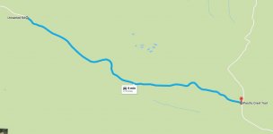
12. After turning right at T-Line go a couple hundred yards or so and you will see a left hand turn onto Private Property. Stay on this road for about 1 mile. Please do not leave this road because everything you are around is private. At or around a mile you should see Spring Valley Lake either in front of you as you descend the rocky hill or to your left hand side (driver side) and you will see another brown trailhead marker talking about the High Lakes. You are now there.
Here are directions to the High Lakes. This only gives directions to the first lake, Spring Valley. There is a huge area to play and wheel and explore out there so do your research ahead of time. Please remember pack out what you pack in and if you see any garbage someone left please pack it out too.
All the mileage is based on Google maps not my actual vehicle due to variances on all vehicles. Roughly 50 miles total. If you have any questions please let me know and I will make the directions clearer. Thanks.
1. Staring Location (Reset your odometer here): Chevron, 2501 Notre Dame Boulevard, Chico, CA 95928
2. Drive 11.2 miles up Skyway to the town of Paradise. Skyway is 55 mph and a massive speed trap. Speed at your own risk.

3. From Paradise continue on Skyway. At 18.8 miles you will see Chucks Place gas station on your right hand side. You will now be in Magalia and this is one of your last places to get fuel and snacks for the road.

4. Exit Chucks Place to the right and continue up Skyway. At 28.3 miles you will be entering a small town called Stirling City. The speed limit is 25 mph…I HIGHLY RECOMMEND you follow this speed limit.

5. After leaving Stirling City you will be on a two lane, yes two lane I know it doesn’t look like it, road. This will take you to InSkip. At 34.5 miles you should see an old building on your right that used to be a hotel and a bunch of tractors and storage containers. This is InSkip.

6. After leaving InSkip the road will widen up and feel a bit more normal. Continue on this road until you reach 38.1 miles. You will see what looks to be a Y ahead of you (left side will be paved, right side will be dirt/gravel) and a spot to pull off on the right hand side. Go ahead and pull off the road this is where you will air down.

7. After airing down head right onto the dirt road. The dirt road will only last a short while. At 39.4 miles you will get to a paved road. You should see a sign that says High Lakes, Philbrook Lake and Lake Almanor. Turn right onto the paved road.

8. Once on the paved road keep going. This will only be a couple miles long before you will hit dirt again. You will cross a small one-lane bridge and make a right turn up the hill. At the top of this hill is a big swooping left hand turn SLOW DOWN it catches people off guard and being aired down will not help. Once you are back on the dirt road and reach 43.1 miles you will be in a big clearing that Y’s off. This is the turn for Philbrook Lake. Go left up the hill.

9. After turning left up the hill away from Philbrook Lake keep following this road. At 44.9 miles you will reach a swooping right hand turn but there will also be a Y here. Keep on the main road to the right. If the logging area up the hill is on your right (passenger side) you went the wrong way.

10. Continue on this main road. At 47 miles you will come to another Y, veer to the right down the hill, this will be the better-looking road. Do not go left you will find unhappy people there and you will not be welcome.

11. After veering right at the Y, continue on this road. Next is “T-Line” also known as “The Fire Camp”. You will be at 49.3 miles and see a trailhead marker for the High Lakes and the Pacific Coast Trail. You’re close but not here yet. Turn right at T-Line.

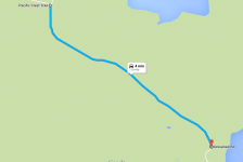
12. After turning right at T-Line go a couple hundred yards or so and you will see a left hand turn onto Private Property. Stay on this road for about 1 mile. Please do not leave this road because everything you are around is private. At or around a mile you should see Spring Valley Lake either in front of you as you descend the rocky hill or to your left hand side (driver side) and you will see another brown trailhead marker talking about the High Lakes. You are now there.


