JEEP TRAIL OFFROAD GPS: What GPS is everyone running?

Speeddmn

New member
Don't know if anything has changed from 2010 till now for the NAV. I have it on my Rubicon and minus the fact it's a PITA to put in a address, the actual map is decent. No TOPO for it, but it does give elevation and lat/long for coordinates. If I were to do it again, I'd still get it just for the function of the rest of the radio itself.
 

olram30

Not That Kind of Engineer
My maps are outdated on my jeep. I get that message. Last I heard, it costs a pretty penny to update. Now I use my cell phone with back country navigator when out in the mountains.
 

spicoli

Member
My maps are outdated on my jeep. I get that message. Last I heard, it costs a pretty penny to update. Now I use my cell phone with back country navigator when out in the mountains.

Is there an app you have used and like? I tried one and wasn't a big fan of it. There are so many GPS programs out there, I don't want to buy more without hearing from someone who uses it for offroading.
 

olram30

Not That Kind of Engineer
Is there an app you have used and like? I tried one and wasn't a big fan of it. There are so many GPS programs out there, I don't want to buy more without hearing from someone who uses it for offroading.

I use back country navigator. I paid 10 bucks for the pro version.
 

Tree Frog

Member
Here is my take for what it is worth;
I got the 430N in my 2013 Rubicon and I think it is a freaking joke. Yeah it works fine on the street/ highway, (not cellular based either) but for most places my S-4 with navigator will do just fine.
What I got it for was the boonies. I would have thought that being a Garmin I could at least get topo.'s and such on it. Nope! In fact a lot of the logging roads we run on are not even on it at all. It just shows the Jeep icon with a blank background.
The color scheme is terrible no matter if you set it for daytime or night. it is a off yellow color and the Forest service/ BLM roads it does show are just a slightly darker off yellow color.

There should be a much higher contrast option. There should be a Topo mode, even if I had to purchase the 100 dollar chip like my Garmin handheld.

I have looked around and I know there are better Off Road GPS systems out there but they are very expensive (at least the ones I have seen.) However this 430N was not cheap either.

Now I really don't think I can live without Sirius/ XM. I even got the version where I can listen to it on my phone and computer. I use it all day at work.
After having it I can not stand to listen to FM any more.

Personally I think Jeep and Garmin could have done a lot better.

I keep hoping somebody will learn how to hack it so we can upload topos and sync. them to work. I know it can be done but you have to be a lot smarter than I am.
I will pay good money for this option. Any takers?

Also note that the Bluetooth part of this thing barely works at all. I have had it in to the dealer and talked with Uconnect and all I got was pissed off. Between the dealer and Uconnect I don't know who is a bigger dumbass. I can buy a 23 dollar POS Bluetooth module from Wal-Mart that works fine, but this Uconnect thing is trash. :naw:
 

jhires

Member
I have the 730n in my JKUR, my wife has the 430n in hers. the 730n is far better than the 430n. Having said that, either one is pretty useless when exploring off main roads.

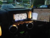
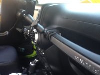
I use an iPad Mini attached to a Ram Mount off the grab bar running Gaia GPS. I make sure I have the maps for the area I will be in before I go out. It's a pain, but the only way to insure I have the maps when I lose cell signal. It's a pain, but the maps are great.

iPad_Mini.jpg

ram_mount.jpg
 

Sessoms14X

Member
Also note that the Bluetooth part of this thing barely works at all. I have had it in to the dealer and talked with Uconnect and all I got was pissed off. Between the dealer and Uconnect I don't know who is a bigger dumbass. I can buy a 23 dollar POS Bluetooth module from Wal-Mart that works fine, but this Uconnect thing is trash. :naw:

I hear ya on that, I can't even keep a call unless I dial it on my phone. If I have the uconnect call someone it will hang up after a few rings but I look at my phone and the call is still going through. I don't even bother with uconnect anymore


Sent from my SM-G900V using WAYALIFE mobile app
 

spicoli

Member
My only concern w/ Uconnect is to be able to play music off my phone. I'm a pretty simple person when it comes to technology. I usually keep it as simple as I can because that way there is less to go wrong, and therefore should be more reliable. K.I.S.S.
 

rich67

Caught the Bug
I use a Garmin Oregon handheld I picked up for $80 and free topo maps off http://www.gpsfiledepot.com/ . I just need a good mounting option for it. I use the DC and USB hookup and it works perfectly, but the dang thing is just so oddly shaped it doesn't sit properly anywhere on the console...lol
 

Wardell

New member
I've been using an Android app called GPS Essentials on my phone. It's one of the few out there that has options for MGRS for coordinates and Mils for bearings, both of which I use at work. It basically does everything a handheld GPS can do as far as waypoints, tracks, etc. Map wise, there are a few options, but I usually just use google's satellite or topo on it - provided I have cell reception that is. That's the only catch with not having a preloaded map. But, I also have a little Garmin hand held that I use most of the time when I'm on foot anyway.

I'm suprised that you can't put Garmin's topo on a 430n though, since it basically uses the same nav program as their other dash mounted GPS units, and I think they can all run the topo maps fine. I may have to do some playing with mine to see if there is a way to transfer it over and get it to display... right after I get a new topo disk anyway, the one I have is a couple years old.
 

ScubaSteve

New member
I'm going to be purchasing or ordering a new 2015 Wrangler here very soon. Around town and road trips I just use my phone for GPS and wouldn't pay for Jeep NAV system to have it built into my dash. But I am curious if it can be used for off-roading navigation (when you don't have cell service) or if there is software that can be loaded onto it for off-road trail navigation.
I am more of an exhibitionist than a rock crawler, so often I come to forks in the road and I have to pull out my big old red map to figure out which way I need to go.
Also I don't know if there is a topo option or if it is always the 5 feet off the ground view that those non-built into the dash units always have. I prefer topo maps.

Thanks in advance for your input and advice.

iPad with Gaia works well.

I prefer standalone GPS so you aren't dependent on cell / data signals. Don't have to mess with downloading maps. Most Topo maps cover large regions of the US. Garmin Montana handheld is pretty cool if you have multiple uses for your gps. Works well in Jeep, motorbikes, hiking, boating and costs $5-$600. If you want a standalone unit for the Jeep Lowrance makes the HDS-5 for about $500. I personally have the HDS-8 because I got a good deal on a used unit, otherwise I would have gotten the 5. It really comes down to personal preference... Hope this helps.
 

JaySC

Member
I have the 730n in my JKUR, my wife has the 430n in hers. the 730n is far better than the 430n. Having said that, either one is pretty useless when exploring off main roads.

I use an iPad Mini attached to a Ram Mount off the grab bar running Gaia GPS. I make sure I have the maps for the area I will be in before I go out. It's a pain, but the only way to insure I have the maps when I lose cell signal. It's a pain, but the maps are great.

View attachment 103511

View attachment 103510

I have a similar set up to yours...unfortunately, I'm not as tech savvy so I'm still trying to figure out how to use GAIA in areas where there is no reception. Question for ya, how fast/slow does your ipad mini take to load a map or to transition from one area of the map to another? Mine seems to take forever, and I could have already driven to Russia before the screen finishes loading. :icon_crazy:
 

2011jk

Member
iPad with Gaia works well.

I prefer standalone GPS so you aren't dependent on cell / data signals. Don't have to mess with downloading maps. Most Topo maps cover large regions of the US. Garmin Montana handheld is pretty cool if you have multiple uses for your gps. Works well in Jeep, motorbikes, hiking, boating and costs $5-$600. If you want a standalone unit for the Jeep Lowrance makes the HDS-5 for about $500. I personally have the HDS-8 because I got a good deal on a used unit, otherwise I would have gotten the 5. It really comes down to personal preference... Hope this helps.


Pictures of how its mounted..
 

SmokinV10

Caught the Bug
I have a Lowrance HDS5 that I picked up used a few weeks ago. I haven't turned it on or mounted it since the most logical place to put it seems to be the passenger grab bar. I just don't want the unit implanted in the passenger's face if the airbag were to deploy.
 

jhires

Member
I have a similar set up to yours...unfortunately, I'm not as tech savvy so I'm still trying to figure out how to use GAIA in areas where there is no reception. Question for ya, how fast/slow does your ipad mini take to load a map or to transition from one area of the map to another? Mine seems to take forever, and I could have already driven to Russia before the screen finishes loading. :icon_crazy:

It does "ok". When I know the area I want to be in, I jump through the hoops of either downloading a map area, or using the option to download maps for a specific track. I use both the website on my desktop and the ipad to do this. Once I've done that, I go first explore the map to see how much of the data is there, then to test it, I put it in airplane mode and do the same again.

I've only had a couple of instances where I outran the map loading,and once I have it set on a specific map layer, I leave it there. but usually I'm not going fast enough to do that.
I've also had it crash on me a few times.

Jesse
 

JaySC

Member
It does "ok". When I know the area I want to be in, I jump through the hoops of either downloading a map area, or using the option to download maps for a specific track. I use both the website on my desktop and the ipad to do this. Once I've done that, I go first explore the map to see how much of the data is there, then to test it, I put it in airplane mode and do the same again.

I've only had a couple of instances where I outran the map loading,and once I have it set on a specific map layer, I leave it there. but usually I'm not going fast enough to do that.
I've also had it crash on me a few times.

Jesse

Thanks for the info Jesse.

Sent from my SCH-I605 using WAYALIFE mobile app
 

olram30

Not That Kind of Engineer
I have a Lowrance HDS5 that I picked up used a few weeks ago. I haven't turned it on or mounted it since the most logical place to put it seems to be the passenger grab bar. I just don't want the unit implanted in the passenger's face if the airbag were to deploy.

give you a $100 bucks for it.
 

JAGS

Hooked
I have a Lowrance HDS5 that I picked up used a few weeks ago. I haven't turned it on or mounted it since the most logical place to put it seems to be the passenger grab bar. I just don't want the unit implanted in the passenger's face if the airbag were to deploy.

Why do you need nav? Get lost on the way to work....or maybe the roads to your new house aren't finished yet??? ;):cheesy:

You seriously need to get that thing offroad dude. Those shocks won't flex themselves ya know. :crazyeyes:
 
Top Bottom