CONCRETE ARROW QUEST : Search for Transcontinental Airway Beacons

Headed out to Southern Colorado for some much needed camping and get away time. This here is Airway Beacon #48, on the El Paso - Pueblo route. According to the NGS data sheet, it was "first observed" in 1945 which seems a bit late considering the main purpose of the beacons. I dont think that is the original build date.

Not sure if this is the same beacon, but it's described as Beacon #45 on the El Paso-Puebla route. It's located on the CO/NM border near the City of Raton. The exact location is 37°02'14.9"N, 104°19'52.7"W. Recent photos show it to be in very good condition. Apparently it's on property owned by the City of Raton. There are lots of pics of the beacon so I'm thinking they're OK with visitors. I found it on:
http://sometimes-interesting.com/2013/12/04/concrete-arrows-and-the-u-s-airmail-beacon-system/. Good hunting!

That's a different one than this one, but I was sorely tempted to make the extra little drive down there since I was so close. I was actually supposed to make this camping trip last weekend and go there with the extra day, I had it planned out and everything. And yeah, good condition with tower and shack both there. No arrow though based on google earth. There is another East of Walsenburg on HWY 10 on top of a butte, but it doesnt look good on google earth.
 
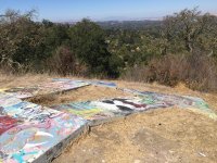
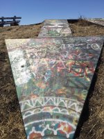
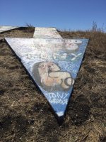
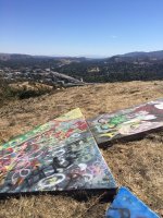
So kitty and I loaded up the dogs into the jeep this morning and headed out to find the arrows near walnut creek and just a short drive and easy hike we found these ImageUploadedByWAYALIFE1442701737.398956.jpg
ImageUploadedByWAYALIFE1442701782.653795.jpg
ImageUploadedByWAYALIFE1442701828.358054.jpg
ImageUploadedByWAYALIFE1442701853.749218.jpg
ImageUploadedByWAYALIFE1442701884.458563.jpg
ImageUploadedByWAYALIFE1442701900.967639.jpg
So cool! hard to believe these are hiding close to home
 
So kitty and I loaded up the dogs into the jeep this morning and headed out to find the arrows near walnut creek and just a short drive and easy hike we found these

So cool! hard to believe these are hiding close to home

Thanks for sharing. Nice find guys!

Looks like some modern-day petroglyphs too.
 
Nice find!
Looks like the idiots found them too.

Idiocy knows no class.

Thanks for sharing. Nice find guys!

Looks like some modern-day petroglyphs too.

Yes I was disappointed in the destruction. There was a bench up there too, looks like the first person actually tried to make it a pretty nice art project and some knuckleheads had to ruin it. The broken glass everywhere was even more disappointing. The views were great - My Diablo to the left of us. Am assuming these arrows were for the Planes coming out of Oakland since the Bay was right behind us over another ridge. Fun day!
 
So kitty and I loaded up the dogs into the jeep this morning and headed out to find the arrows near walnut creek and just a short drive and easy hike we found these View attachment 165520
View attachment 165521
View attachment 165522
View attachment 165523
View attachment 165524
View attachment 165525
So cool! hard to believe these are hiding close to home

Awesome!! I have been eyeing this one for some time now and if I recall, you and I had talked about it in the past. It really is a shame that it's all tagged up like that but, it's still a real gem especially being that it's still there at all. Love the fact that it has 2 arrows for 2 different routes. Thank you so much for posting this up :thumb:
 
Yes I was disappointed in the destruction. There was a bench up there too, looks like the first person actually tried to make it a pretty nice art project and some knuckleheads had to ruin it. The broken glass everywhere was even more disappointing. The views were great - My Diablo to the left of us. Am assuming these arrows were for the Planes coming out of Oakland since the Bay was right behind us over another ridge. Fun day!

That really is a shame to hear especially being that it really does look like a pretty spot. Glad that you make the trek though and were able to share what you found :thumb:
 
Wow! Great find! This is the first time I've seen two arrows together. Pretty cool! Glad you guys explored these out. [emoji106]
 
CONCRETE ARROW QUEST : Search for Transcontinental Airway Beacons - Part 8

Being that it was my birthday last week, Cindy and I decided to drop what we were doing, load up our Jeep and head out to the Northern Nevada Desert to look for some concrete arrows, also known as, Transcontinental Airway Beacons. As some of you may know, we've been looking for and photographing these 50 ft. arrows and on occasion, towers as well for over two years now and on this trip, it was our hope to find a few located all the way out on the eastern edge of the state. Of course, it'd be near impossible for us to not explore some old ghost towns and do a bit of rock hounding along the way and in this thread, you'll get to see a little bit of all the things we got to see and do. I hope you enjoy :cool:

Here's a shot of us making our way out to our first destination of the day, Derby Field.
main.php


Located southwest of the town of Lovelock, Derby Field is an operational airport that planes that services the area. Of course, what makes this airway beacon so cool is that its original tower is still standing here and is still in use.
main.php


As you can see in the sky above, this airway route is one that is still in use to this very day.
main.php


Closer shot of the beacon and red lights as well as a windsock still flying from the tower.
main.php


main.php


Sometimes, broken pieces of glass from old bulbs and lenses can be found around these towers.
main.php


main.php


On our way to our next concrete arrow, Cindy and I got distracted by a nearby side route that we've been meaning to explore and so, we changed course and headed up into the Humboldt Mountains.
main.php


main.php


As we approached the old ghost town of Humboldt City, we made a stop, hiked up into the hills and went looking for the old town cemetery. Being that there was no road to it, no signs and just rocks to mark the graves, it was pretty hard to find but we eventually found it.
main.php


This nameless headstone marked one of about a dozen graves.
main.php


This rock was etched with the letters "MT" as well as a date that I believe said 1895.
main.php


The coffin in this grave must have collapsed as there was a depression here as well as a hole leading into it.
main.php


Anybody home?
main.php


Pulling into Humboldt City.
main.php


At the old ghost town of Humboldt City.
main.php


main.php


Some shots from around town.
main.php


main.php


main.php


main.php


main.php


main.php


main.php


main.php


The walls of an old Wells Fargo bank.
main.php


main.php


main.php


Inside the remaining structure.
main.php


main.php


main.php


main.php


After our fun exploring Humboldt City, we hustled out to another concrete arrow out in the Buffalo Valley that we had been meaning to check out but, thanks to winter offering up such little daylight, we just had enough time to do a little filming and snap a few shots at sunset. And, here they are.
main.php


main.php


main.php


main.php


Unlike any other airway beacon we have come across, this one featured intricately constructed concrete curbs and what looked like driveways and even a central garden with a path to a flag pole.
main.php


To the eastern edge of the site was a pathway lined with rocks that lead to a small reservoir.
main.php


Nearby was also some kind of vault or cistern in the ground.
main.php


There were also these strange metal cones that still had a bit of orange paint on them.
main.php


From what I understand, this location also served as an airfield and further past the arrow was another foundation of some sort complete with what looked like additional generator mounts.
main.php


Beyond it was the foundation to some kind of storage tank.
main.php


A parting shot before we made our way back to civilization.
main.php


Flying though a tunnel near Carlin as we made our way out to Elko.
main.php


Happy Birthday to me - CHEERS from the Machi's Saloon!
main.php
 
Day 2

The following morning, we loaded up and headed to the eastern edge of Nevada to look for a unique airway beacon that was on top of a steep hill and has a concrete arrows in the shape of a right angle. While there are a lot of arrow that have slight course corrections, most are slight angles to the left or the right so this one was really different. Also, because of it's location, the generator shed was actually located at the bottom of the hill as opposed to being built directly on top of the tail as is normally the case. Needless to say, this was a great find!

Here's a shot from the bottom of the hill where the generator shed was located.
main.php


main.php


Foundation for the generator.
main.php


Shot of Rubicat next to the concrete arrow on top of the hill.
main.php


Here you can get a better view of the right angle the concrete arrow makes.
main.php


main.php


After repositioning Rubicat, we took a few more shots.
main.php


main.php


main.php


View looking toward the tail of the concrete arrow which points to the south.
main.php


Middle of the arrow where the tower would have stood.
main.php


View down the point of the concrete arrow and to the east where you can see I-80 and Utah in the distance.
main.php


After our fun near the Utah state border, we headed back west and then to the north until we just crossed into the Idaho border. And, it was here that we decided to do some rockhouding. Or, as much as we could before the we lost all our daylight anyway.
main.php


Along the top of a small hill and embedded within the basalt layer, there are nodules containing geodes that you can find here. This one was empty but, you get the idea.
main.php


Here's a chunk of basalt that had a bunch of nodules but they have all been removed.
main.php


Unfortunately, we didn't find much of anything but then, we didn't have as much time as we would have preferred either. Time to find our home for the night.
main.php


For our second night on the road, we stayed in Jackpot, Nevada although, it probably should be Jackpot, Idaho. Not only is everyone there from Idaho, they even unofficially recognize Mountain Time there just like you would in Idaho. Anyway, here's to a fun day out on the trail - CHEERS!!
main.php
 
Our third day in search of concrete arrows would take us back into Nevada and out to the tiny town of Welcome. Just in case you don't know where this it's just west of Beverly Hills, NV. :crazyeyes:
main.php


main.php


Like so many of the airway beacons all across the country, many were perfect locations to erect radio and cellular towers and this one was no exception.
main.php


As you can see, they literally built on the exact same spot as where the beacon once stood and to a degree, built right into it as well.
main.php


main.php


After some discussion, we decided to head back into the Buffalo Valley to check out a few things we missed the day before.
main.php


main.php


main.php


After driving out into the middle of the valley and then hiking even further into it, we found what we were looking for - a whole host of hot springs like this.
main.php


main.php


main.php


main.php


main.php


main.php


Some of the hot springs cascaded down beautiful and colorful terraces.
main.php


main.php


The landscape out here was totally alien.
main.php


main.php


main.php


main.php


Time to head back to Rubicat - can you see her?
main.php


What a great day but unfortunately, daylight is leaving us once again.
main.php


On our way home, we stopped in the town of Austin and took some time to pose for a shot under the glow of the Stokes Castle.
main.php


main.php


Of course, what would a trip out in the Northern Nevada Desert be without a dinner stop over at the historic Middlegate Station - population 17.
main.php


main.php


The saloon is awesome.
main.php


The food is outstanding too!
main.php


To the end of a great birthday weekend - CHEERS!! :cool:
main.php


To see all the other Arrow Quests we've done over the years, simply click on the following link:

CONCRETE ARROW QUEST : Search for Transcontinental Airway Beacons

:cool:
 
so those awesomely weird looking formations were hot springs!?! how cool! as usual amazing shots to go along with an awesome adventure
 
Top Bottom